
Grade 5 | Lesson 2
Dean of Students: dean@theschools.com
Tech Services: tech@theschools.com
Grade 5 | Lesson 2
Dean of Students: dean@theschools.com
Tech Services: tech@theschools.com
Social Sciences
Lesson Overview
Geography
• Where on Earth Are You?
Activating History
• The Arctic Circle, Antarctic and the Tropics
![]()
Geography
Where on Earth Are You?
If you live in the United States, you live in the Western Hemisphere, which includes all parts of the world west of the prime meridian and east of the 180 degree meridian. Since a hemisphere is one half of the world, knowing which half you live in doesn’t really pinpoint your exact location, does it? Let’s take another step. You know that the world is also divided in half by the equator. The half above the equator is called the Northern Hemisphere, and the half below the equator is the Southern Hemisphere.
If the world were a grapefruit and you cut it in half both vertically and horizontally, you would have four quarters of it to consider. Geographers call these quarters quadrants, from a Latin word meaning fourth part. Can you see that the United States is in the northwestern quadrant of the world?
Locating your quadrant on the globe is helpful but it still doesn’t show anyone exactly where you live. To do this, you’ll need a map of where you live (we'll assume that you live in the town of Richmond in the state of Virginia in the United State, but this will work for anywhere on the globe). Take a look at the three maps that follow. Notice how much more detail is included on each map. Although not meant for close study, the U.S. map shows all fifty states, while the state map focuses on just one state. A U.S. map shows many more miles of the earth’s surface than a state map, and a state map shows many more miles of surface than a town map. Each map is drawn to a different scale. Scale is the proportion between distance on the map and actual distance on the earth’s surface. For instance, on one map a distance of one inch can represent one real mile; on another an inch can represent a hundred miles.


Do you think we could use a forth map? Sure! It depends on where you live, but street specific maps usually require a 4th or even 5th map.
![]()
Activating History
Use a printed or online atlas of the United States and a map of your town to write directions to your home for a visitor from another town. You should be able to find the maps you need on the Internet. First locate your town and your visitor’s town in the U.S. atlas, and write down the set of roads that most directly connect them. Be sure to write your instructions as though traveling from your visitor’s town to your own, and include compass directions and the number of mile to major turning points (for example, "Take Route 29 traveling north for twelve miles until you reach the intersection of Routes 29 and 33 . . ."). Once you’ve completed directions to the outskirts of your town, turn to your town map and use it to write directions to your street from the outskirts of town.
![]()
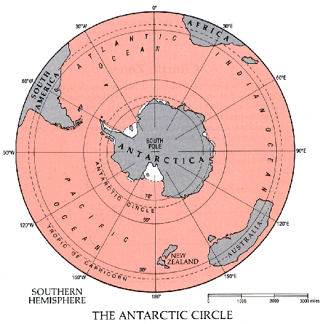
The Arctic Circle, Antarctic and the Tropics
Geographers divide the earth another way - in bands that are parallel to the equator. Those bands tell you a lot about the climate of those regions of the earth. The farther from the equator in either direction, the colder the climate tends to be.
Let’s go back and look at the Northern Hemisphere again. Far to the north, at about 67 degrees N latitude, there is an imaginary boundary called the Arctic Circle.
The lands and waters north of the Arctic Circle are called the Arctic Region. You can look at the lands inside the Arctic Circle in a new way on the map that follows from a spot above the North Pole! You’ll notice that these lands form a ring around a large body of water known as the Arctic Ocean. Much of this ocean remains frozen year after year in a thick pack of ice that floats on the surface. This is called the polar ice cap.

What's the weather report at Barrow, Alaska, part of the United States close to the North Pole?
On the other side of the world, in the Southern Hemisphere, there is another imaginary circle called the Antarctic Circle, located at about 67 degree S latitude. The prefix "anti-" means "opposite of" in Greek. The Antarctic is opposite the Arctic on a globe or map. Find the South Pole. See how it’s surrounded by the continent of Antarctica? Use the scale of miles on the map to approximate how many miles it is from the southern tip of South America to the Antarctic Circle.
The Antarctic climate is even colder than that of the Arctic. Although mountains do stick out along the coast and in central parts of the continent, most Antarctic lands are buried under a permanent ice cap big enough to cover the entire United States in a layer two miles thick! This southern polar ice cap contains over 75 percent of the world’s fresh water.
Take me now to live cameras at Antarctica, and let me click on today's weather report there.
Do you think there was ever a time that Antarctica didn't have ice?
Now let’s find two more imaginary circles, the Tropic of Cancer and the Tropic of Capricorn. Both of these circles lie parallel to the equator at about 23 degrees latitude: the Tropic of Cancer to the north, and the Tropic of Capricorn to the south. Their names came down to us from ancient astronomers who named them for constellations called Cancer (which means crab in Latin) and Capricorn (which means goat horn).

These two circles mark the northern- and southernmost boundaries of the region known as the Tropics.